A bicycle network is an integrated, cohesive set of protected bicycle lanes that provide access to calm streets within 30 km/h Low Traffic Neighbourhoods, enabling people of all ages and abilities to safely cycle to any destination in Yarra.
Benefits
A bicycle network would deliver the following benefits:
- Enable local residents to easily access local traders, making Yarra better for business,
- Enable those who wish to cycle to be able to do, thus reducing congestion and making Yarra better for drivers,
- Comply with federal, state and local government policies on road safety, and
- Help people in the City of Yarra respond to our climate emergency.
Where people want to go
People who ride bikes want to be able to safely access every property in Yarra.

Best practice
The Dutch Cycling Embassy highlights five principles for a successful bicycle network:
Cohesion
Directness
Safety
Comfort
Attractiveness
What Yarra can do
Yarra can build a network of protected bicycle lanes that link 30 km/h Low Traffic Neighbourhoods. This would deliver mobility and access over the entire municipality for the least cost.

Status
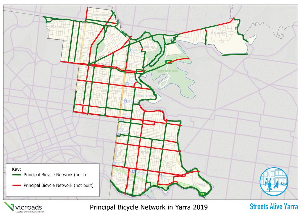
The image below shows the present status of the VicRoads/DoT Principal Bicycle Network. Clearly, many sections (shown in red) are missing. In addition, most neighbourhoods have not yet been calmed to 30 km/h.
History
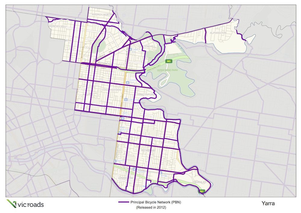
VicRoads published the Principal Bicycle Network (PBN) in 2012:
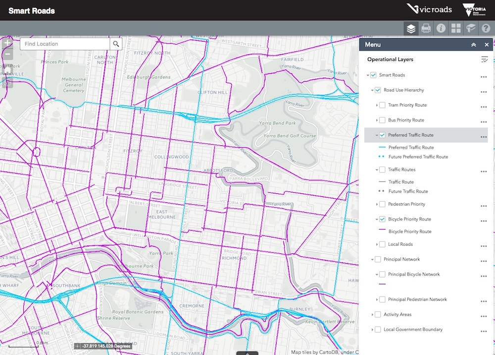
VicRoads then narrowed their focus to Bicycle Priority Routes, a subset of the Principal Bicycle Network, shown in pink below:
Department of Transport (VicRoads) then further narrowed their focus to Strategic Cycling Corridors. Both the pink and blue lines on the map are strategic cycling corridors, with pink lines representing the highest priority routes, and blue lines the next highest:

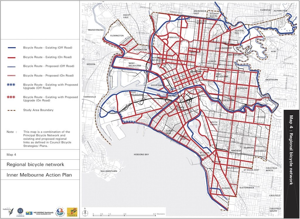
In parallel, the Inner Melbourne Action Plan (IMAP), a collaborative partnership between several Councils, published a map of their proposed inner Melbourne bicycle network. Unfortunately it hasn’t been completed, and some sections marked as ‘existing’ are only a strip of paint, not a protected bicycle lane.
Problem
The problem is that state government hasn’t actually constructed the Principal Bicycle Network, or even the Strategic Cycling Corridors. For example, Swan Street doesn’t have any bicycle lane markings at all. The most likely reason for the delay is that traders protest against the loss of on-street parking on shopping streets, even though studies show that changes would be better for business.
Solution
The solution is for local and state government to collaborate to enable traders and residents to trial how good shopping streets could be if wider footpaths, protected bicycle lanes, and level access tram stops were built. Once trials are complete, and traders can see that their business will benefit, the complete set of Strategic Cycling Corridors can be built, followed by the entire Principal Bicycle Network. This would all be part of implementing the Victorian Cycling Strategy:
Strategic cycling corridors are the arterials of the bicycle network, which join up important destinations: the central city, national employment and innovation clusters, major activity centres and other destinations of metropolitan and state significance. We will prioritise strategic cycling corridors for investment to deliver safer, more direct cycling into and across Melbourne and Victoria. We will work with others to update guidelines for strategic cycling corridors to ensure a consistent approach to developing a high- quality network of cycling infrastructure.
Victorian Cycling Strategy 2018-2028
We will work with local councils to join up strategic cycling corridors on local streets, arterial roads, highways, rail corridors and green spaces. We will work closely with local councils to plan, identify and deliver improvements to strategic cycling corridors and to support the 20-minute neighbourhood concept, especially for cycling to schools, train stations and activity areas.
Victorian Cycling Strategy 2018-2028
Supporters
Supporters of networks of safe cycling infrastructure, including protected bicycle lanes, include We Ride Australia:
How you can help
You can help by appearing on the Streets Alive Yarra website as a champion for your local street, neighbourhood, or school.