The City of Yarra can learn from other municipalities in Victoria, as we draft our upcoming Integrated Transport Plan. One municipality that we can look at is Yarra Ranges Council, who have adopted an Integrated Transport Strategy:
Our community members have told us that while they rely on their cars, they also want more public transport with better connections between modes, better footpaths, more walkable neighbourhoods and cycling networks separated from roads.
Yarra Ranges Council Integrated Transport Strategy
We know that most car trips in the Yarra Ranges are less than three kilometres long. While there are many members of the community who will need to take trips by car, we also know that by improving the infrastructure people use to walk and ride, more people will be able to make those journeys on foot or by bike. Regardless of how you travel, this strategy identifies the need for us to have more bike paths and lanes separated from road traffic, to avoid both vehicles and bike traffic mixing in unsafe ways.
Yarra Ranges Council Integrated Transport Strategy
The case for change
The strategy’s case for change can also be applied to the City of Yarra:
The traditional approach to transport planning has not delivered the best outcomes for the community. Traffic and parking congestion remains a pressing issue, growing risks from climate change requires a decrease in emissions from transport, and most of our townships are already built-out, with little room to expand or widen roads. Melbourne’s population continues to increase, and Yarra Ranges will need to accommodate some of this growth. We have reached the maximum supply for our road network.
Yarra Ranges Council Integrated Transport Strategy
There are limited opportunities to widen roads or add new lanes. Additional population growth will need to be managed within the existing transport network. To make sure the road network is suitable for those that need to drive, we will provide more attractive options for those trips that can be done by foot, bicycle or public transport. Developing a suite of actions that make it easier for people to leave the car at home and jump on a bike or take a stroll to the shops will help replace many of the ~1,000,000 car trips under 3km that take place every week in Yarra Ranges. This will allow us to absorb a growing population without increasing the number of cars on our roads.
Yarra Ranges Council Integrated Transport Strategy
What Yarra Ranges will do
The strategy’s actions can also be applied to the City of Yarra:
We will increase opportunities for people to walk and cycle to local destinations, including shops, schools, and train stations. Just over half of all car trips in Yarra Ranges are less than 3km. While some of these trips will need to be done by car, there are many that could be easily completed by walking (less than 1km) or cycling (less than 3km) if the right infrastructure was provided. We will expand the current walking and cycling network to allow people the opportunity to walk and cycle. This category represents the biggest opportunity for Yarra Ranges Council to reduce local traffic and parking congestion.
Yarra Ranges Council Integrated Transport Strategy
The big issues facing Yarra Ranges
Most of the big issues identified by the strategy also apply to the City of Yarra, including:
- climate change
- traffic issues associate with population growth
- public health
- economic development
- road safety
- equity of access
The exception is “low density” – the City of Yarra has higher density, which makes it easier to deliver the strategy.
Strategic objectives
The five strategic objectives identified by the strategy can be applied to the City of Yarra:
- Connected and healthy communities
- Quality infrastructure and liveable places
- Protected and enhanced natural environment
- Vibrant economy
- High performing organisation
Vision and guiding principles
The vision and guiding principles can be applied to the City of Yarra
Mode hierarchy
The mode hierarchy defined by the strategy for town centres, can be applied to the City of Yarra
Street innovation
Many of the streets in Yarra Ranges were designed many decades ago and our transport and liveability challenges have changed markedly since then. It is therefore necessary for our streets to evolve to reflect the changing needs of our community.
Yarra Ranges Council Integrated Transport Strategy
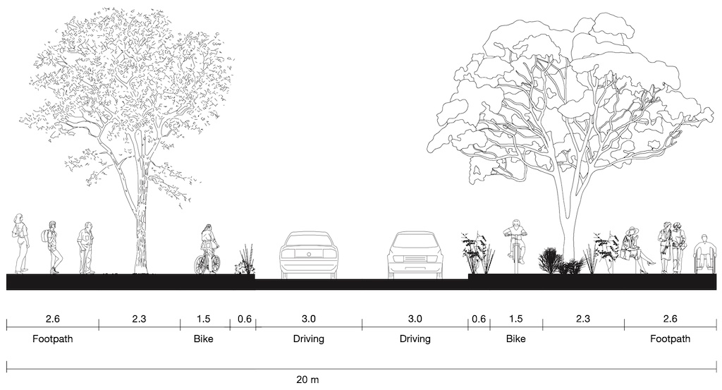
The Yarra Ranges Council strategy proposes to innovate new street designs – one of which is a 22 metre wide design for an activity centre or shopping street.
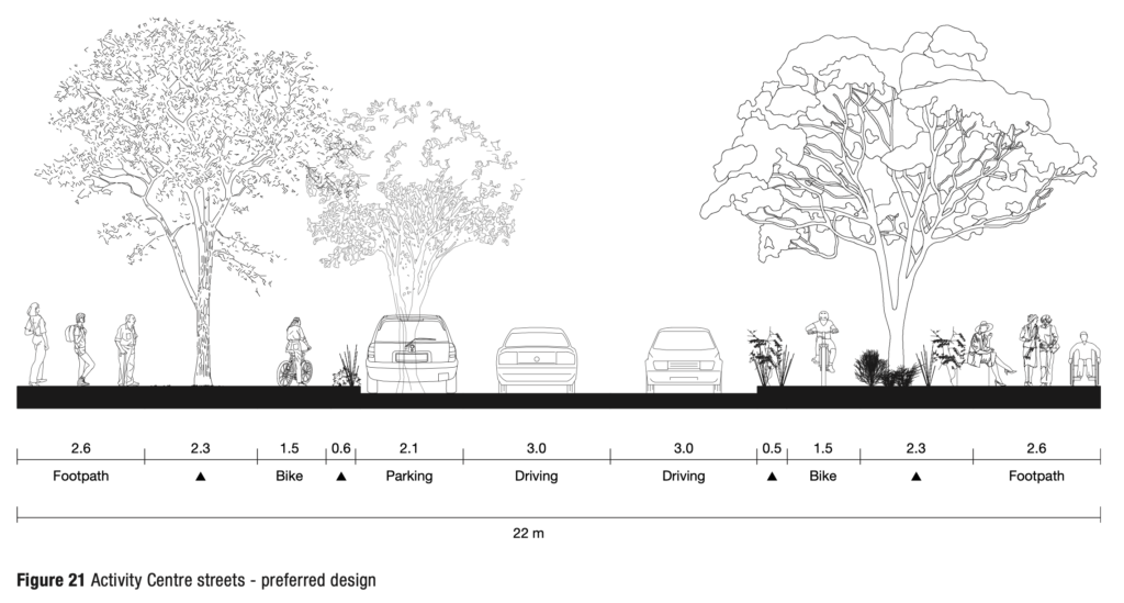
Many shopping streets in the City of Yarra are 20 metres wide – with a slight modification to account for our reduced width, the “preferred design” looks very similar to the “Melbourne Shopping Street” reference design proposed by Streets Alive Yarra, with more trees and protected bicycle lanes:
What Yarra Ranges is not doing
The Yarra Ranges Council strategy also points out what they’re not doing, and why, including building additional car parking.
We know that car parking concerns feature highly on the community’s list of concerns regarding transport issues in Yarra Ranges, especially at train stations. Two major expansions to existing car parking at train stations have been committed to by the State Government. The Mooroolbark and Belgrave train stations will receive hundreds more car parking bays each. When looking at the evidence on other car parking expansions across Melbourne, we know that in most cases, people who previously walked or got public transport to the station are the ones that take up the additional spots. This works against many of the strategic directions of Connected, as well as Council’s wider Strategic Objectives.
Yarra Ranges Council Integrated Transport Strategy
Our view
Streets Alive Yarra applauds Yarra Ranges Council on their Integrated Transport Strategy, and suggests that much of the content can be applied to the City of Yarra. We hope that Councillors, Officers and residents have a chance to read it.
Published 7th December 2020